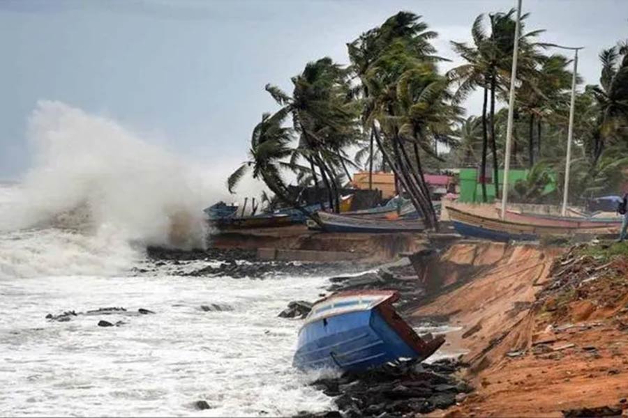
বঙ্গোপসাগরের ঘূর্ণিঝড় মোখা ক্রমশ উপকুলের দিকে এগিয়ে আসতে থাকায় এবং এর তীব্রতা বাড়তে থাকায় বাংলাদেশ আবহাওয়া অধিদপ্তর আট নম্বর মহাবিপদ সংকেত জারি করেছে।
আবহাওয়া অধিদপ্তরের সর্বশেষ পূর্বাভাসে চট্টগ্রাম, কক্সবাজার, এবং পায়রা সমুদ্রবন্দরকে চার নম্বর স্থানীয় হুঁশিয়ারি সংকেত নামিয়ে তার জায়গায় আট নম্বর মহাবিপদ সংকেত দেখাতে বলা হয়েছে।
আট নম্বর মহাবিপদ সংকেতের মানে হচ্ছে বন্দর প্রচণ্ড বা সর্বোচ্চ মাত্রার ঘূর্ণিঝড়ের কবলে পড়তে পারে। ঝড়ে বাতাসের সর্বোচ্চ একটানা গতিবেগ ঘণ্টায় ৮৯ কিলোমিটার বা এর বেশি হতে পারে। প্রচণ্ড ঝড়টি বন্দরকে বামদিকে রেখে উপকুল অতিক্রম করবে।
আবহাওয়া অধিদপ্তর তাদের সর্বশেষ পূর্বাভাসে জানায়, ঘূর্ণিঝড়টি সর্বশেষ পূর্ব-মধ্য বঙ্গোপসাগর এবং তৎসংলগ্ন এলাকায় অবস্থান করছে। শুক্রবার সন্ধ্যা ছয়টায় এটি ছিল চট্টগ্রাম সমুদ্রবন্দর থেকে ৯৩০ কিলোমিটার, কক্সবাজার সমুদ্রবন্দর থেকে ৮৬০ কিলোমিটার, মোংলা সমুদ্রবন্দর থেকে ৮৯০ কিলোমিটার এবং পায়রা সমুদ্রবন্দর থেকে ৮৫৫ কিলোমিটার দক্ষিণ-দক্ষিণপশ্চিমে। এটি আরও উত্তর-উত্তর-পূর্ব দিকে অগ্রসর হচ্ছে এবং ১৪ মে সকাল ছয়টা হতে সন্ধ্যা ছয়টার মধ্যে কক্সবাজার-উত্তর মিয়ানমার উপকূল অতিক্রম করতে পারে।
ঘূর্ণিঝড়টির কেন্দ্রের ৭৪ কিলোমিটার এলাকার মধ্যে বাতাসের সর্বোচ্চ গতি এখন ঘণ্টায় ১৪০ কিলোমিটার, তবে দমকা এবং ঝড়ো হাওয়ার আকারে তা ১৬০ কিলোমিটার পর্যন্ত বাড়ছে। ঘূর্ণিঝড় কেন্দ্রের কাছে সাগর এখন বেশ বিক্ষুব্ধ।
উপকূলীয় জেলা কক্সবাজার, চট্টগ্রাম, ফেনী, নোয়াখালী, লক্ষ্মীপুর, চাঁদপুর, বরিশাল, ভোলা, পটুয়াখালী, ঝালকাঠি, পিরোজপুর, বরগুনা এবং তাদের ও দূরবর্তী দ্বীপ এবং চরগুলো ৮ নম্বর মহাবিপদ সংকেতের আওতায় থাকবে।
ঘূর্ণিঝড়টির অগ্রবর্তী অংশ এবং বায়ুর চাপ পার্থক্যের কারণে উপকূলীয় জেলা কক্সবাজার, চট্টগ্রাম এবং তাদের অদূরবর্তী দ্বীপ এবং চরে স্বাভাবিকের চেয়ে ৮ হতে ১২ ফুট বেশি উচ্চতার জলোচ্ছ্বাস হতে পারে।
এছাড়া ফেনী, নোয়াখালী, লক্ষীপুর, চাঁদপুর, বরিশাল, ভোলা, পটুয়াখালী, ঝালকাঠি, পিরোজপুর, বরগুনা এবং সেখানকার দ্বীপ এবং চরে স্বাভাবিক জোয়ারের চেয়ে পাঁচ হতে সাত ফুটের বেশি উচ্চতার জলোচ্ছ্বাসের হতে পারে।
উত্তর বঙ্গোপসাগরের সব মাছধরা নৌকা এবং ট্রলারকে নিরাপদ আশ্রয়ে চলে যেতে বলা হয়েছে।
আবহাওয়া অধিদপ্তরের পরিচালক আজিজুর রহমান আজ এক সংবাদ সম্মেলনে আশঙ্কা প্রকাশ করেন যে এটি উপকূলের কাছে যখন আসবে তখন এর কেন্দ্রে বাতাসের গতিবেগ আরো বাড়তে পারে।
তিনি বলেন, “এটির তীব্রতা ক্রমান্বয়ে বাড়ছে। এটির প্যাটার্ন আগে ছিল সিডিইউ, এখন এটি ব্যান্ড প্যাটার্নে রূপ নিয়েছে।”
এই ধরণ পরিবর্তনের কারণে ঘূর্ণিঝড়ে বাতাসের বেগ বেড়ে যায় এবং বৃষ্টিপাতের তীব্রতাও বেড়ে যায় বলে জানান মি. রহমান।
পাশাপাশি বজ্রপাতের পরিমাণও বাড়ার কথা উল্লেখ করেন মি. রহমান।
মোখা কি সিডরের মত সুপার সাইক্লোন হতে পারে?
আবহাওয়া অধিদপ্তরের আবহাওয়াবিদ উমর ফারুক বিবিসিকে জানান যে এটি এখনো অতি প্রবল ঘূর্ণিঝড় অবস্থায় রয়েছে। তবে সিডরের মত সুপার সাইক্লোনে পরিণত হবে কিনা, তা এখনো নিশ্চিতভাবে বলা যাচ্ছে না।
আবহাওয়াবিদ উমর ফারুক বলেন, “সিডর ছিল সুপার সাইক্লোন। মোখা এখনো অতি প্রবল ঘূর্ণিঝড়। যদিও এর কেন্দ্রে বাতাসের গতিবেগ বাড়ছে, কিন্তু এটি সুপার সাইক্লোনে পরিণত হতে পারে কিনা, তা এখনই বলা যাচ্ছে না।”
ঘূর্ণিঝড়ের কেন্দ্রে বাতাসের গতিবেগ যদি ৬২ থেকে ৮৮ কিলোমিটারের মধ্যে থাকে, তাহলে সেটিকে স্বাভাবিক ঘূর্ণিঝড় বলা হয়। কেন্দ্রে বাতাসের গতিবেগ ৮৯ থেকে ১১৭ কিলোমিটারের মধ্যে হলে সেটি প্রবল ঘূর্ণিঝড় আর বাতাসের গতিবেগ ১১৮ থেকে ২২০ কিলোমিটারের মধ্যে হলে সেটিকে অতি প্রবল ঘূর্ণিঝড় হিসেবে চিহ্নিত করা হয়।
আর বাতাসের গতিবেগ যদি ঘণ্টায় ২২০ কিলোমিটারের বেশি হয়ে থাকে তাহলে সেটিকে সুপার সাইক্লোন বলা হয়।
দুই হাজার সাত সালে হওয়া সিডর ছিল সুপার সাইক্লোন। ঐ বছরের নভেম্বরে হওয়া ঐ ঘূর্ণিঝড়ের কেন্দ্রে বাতাসের বেগ ছিল ঘণ্টায় প্রায় ২৬০ কিলোমিটার।
এর আগে বাংলাদেশে ১৯৯১ সালে চট্টগ্রাম উপকূলে আঘাত হানা ঘূর্ণিঝড়ের ক্ষেত্রে বাতাসের গতিবেগ ছিল ঘণ্টায় ২২৫ কিলোমিটার।
আজ সকালে আবহাওয়া অধিদপ্তরের পরিচালক আজিজুর রহমান এক সংবাদ সম্মেলনে জানান যে এটি সুপার সাইক্লোনে পরিণত হবে, সূচক বিশ্লেষণ করে এখনো সেরকম কিছু বলা যাবে না।
তবে এটিকে সুপার সাইক্লোনে পরিণত হওয়ার সম্ভাবনা উড়িয়ে দিচ্ছেন না তিনি।
মি. রহমান বলেন, “এটি সুপার সাইক্লোনে পরিণত হবে বা হবে না, এখনই এটি বলা যাচ্ছে না। এই ঘূর্ণিঝড়টির ক্ষেত্রে কেন্দ্রের ব্যাস, কেন্দ্রে বাতাসের গতিবেগ সবই বাড়ছে। তবে এটি উপকূলের কাছে আসতে এখনও ৪৮ ঘণ্টার মত বাকি। এই সময়ের মধ্যে এটি দুর্বলও হতে পারে।”
আবহাওয়া অধিদপ্তরের পরিচালক চট্টগ্রাম অঞ্চলে বসবাসকারী মানুষকে অতিরিক্ত সতর্কতা অবলম্বন করার আহ্বান জানান।
পাশাপাশি আগামীকাল সন্ধ্যা নাগাদ উপকূলীয় চট্টগ্রাম, খুলনা, বরিশালের মত উপকূল সংলগ্ন অঞ্চলগুলোতে বৃষ্টিপাতের সম্ভাবনা বেড়ে যাবে বলেও জানান তিনি।
গতিপথ কোনদিকে
আবহাওয়াবিদরা বলছেন, বর্তমান গতি প্রকৃতি অনুযায়ী এগোলে বা দিক না পাল্টালে সম্ভাব্য ঘূর্ণিঝড় মোখা ১৪ই মে বাংলাদেশের কক্সবাজার এবং মিয়ানমারের কিয়াকপিউয়ের মধ্যবর্তী এলাকা দিয়ে উপকূল অতিক্রম করতে পারে।
আবহাওয়া অধিদপ্তরের পরিচালকও বলেন যে গত ৫০ বছরের ঘূর্ণিঝড়ের গতিবেগ পর্যালোচনা করলে দেখা যায় যে ঐতিহাসিকভাবে মে মাসের ঘূর্ণিঝড় উত্তর উত্তর-পূর্ব দিকেই ধাবিত হয়েছে।
বিভিন্ন গ্লোবাল মডেল বিশ্লেষণ করে আবহাওয়া বিশেষজ্ঞ মোস্তফা কামাল পলাশ বলছেন “ঘূর্ণিঝড় মোখার অগ্রভাগ ১৪ ই মে সকাল ৬ টার পর থেকে দুপুর ১২টার মধ্যে চট্টগ্রাম বিভাগের উপকূলে আঘাত করার আশঙ্কা রয়েছে। ঘুর্ণিঝড় কেন্দ্র দুপুর থেকে সন্ধ্যা পর্যন্ত ও পিছনের অংশ সন্ধ্যা থেকে ১৫ইমে সোমবার ভোর পর্যন্ত উপকূল অতিক্রম করার সম্ভাবনা রয়েছে”।
এছাড়া ভূমিধসের আশঙ্কাও প্রকাশ করছেন এই আবহাওয়া বিশেষজ্ঞ।
অন্যদিকে আবহাওয়া বিশেষজ্ঞ ড. সমরেন্দ্র কর্মকার বলছেন, এখন যে অবস্থা দেখা যাচ্ছে তাতে মনে হচ্ছে যে বাংলাদেশের উপকূলের দিকে আসছে ঘূর্ণিঝড়টি।
“বাংলাদেশে কক্সবাজার অঞ্চলে কিছু প্রভাব পড়বে। বিশেষ করে এটা টেকনাফের ওপর দিয়ে যাবে মনে হচ্ছে। এই মুহূর্তে যে গতিপথ দেখা যাচ্ছে তাতে মনে হচ্ছে ঘূর্ণিঝড়ের মূল অংশটা টেকনাফ ছূঁয়ে যাবে। হয়তো টেকনাফের একটু দক্ষিণ দিক অতিক্রম করে মিয়ানমারের দিকে চলে যেতে পারে” বলছিলেন মি. কর্মকার।
Cyclone ‘Mokha’ No. 8 disaster signal
The Bangladesh Meteorological Department has issued an eight-distress alert as the Bay of Bengal cyclonic storm is moving towards Upakul and its intensity is increasing. In the latest forecast of the Meteorological Department, Chittagong, Cox’s Bazar, and Payra seaports have been asked to downgrade the local warning signal number four and display the emergency signal number eight in its place. Distress signal number eight means that the port may be hit by a severe or maximum cyclone. Maximum sustained winds in storms may reach 89 km/h or more. The strong storm will cross the port side to the left. According to the Meteorological Department in their latest forecast, the cyclone was last positioned over the east-central Bay of Bengal and adjoining areas. At 6 pm on Friday, it was 930 km from Chittagong seaport, 860 km from Cox’s Bazar seaport, 890 km from Mongla seaport and 855 km from Payra seaport. It is moving further north-northeastward and may cross Cox’s Bazar-North Myanmar coast between 6 am to 6 pm on May 14. Maximum wind speed is now 140 km/h within a 74-km area of the cyclone’s center, but increases to 160 km/h in gusty and gusty forms. The sea near the cyclone center is now quite rough. Coastal districts of Cox’s Bazar, Chittagong, Feni, Noakhali, Lakshmipur, Chandpur, Barisal, Bhola, Patuakhali, Jhalkathi, Pirojpur, Barguna and their and distant islands and outlying islands will be under 8-distress signal. Due to the advance of the cyclone and the difference in air pressure, the coastal districts of Cox’s Bazar, Chittagong and their outlying islands and Char are likely to experience 8 to 12 feet higher than normal tides. Apart from this, Feni, Noakhali, Lakshipur, Chandpur, Barisal, Bhola, Patuakhali, Jhalkathi, Pirojpur, Barguna and the islands and chars there may experience high tide of five to seven feet more than the normal tide. All fishing boats and trawlers in the North Bay of Bengal have been asked to take shelter. Azizur Rahman, director of the Meteorological Department, expressed fear in a press conference today that the wind speed in its center may increase as it approaches the coast. He said, “Its intensity is gradually increasing. Earlier its pattern was CDU, now it has changed to band pattern.” Mr. Rahman In addition, Mr. mentioned the increase in the amount of lightning. Rahman Could Mokha be a super cyclone like Sidr? Meteorological Department meteorologist Umar Farooq told the BBC that it is still a very strong cyclone. However, it cannot be said for sure whether it will become a super cyclone like Sidor. Meteorologist Umar Farooq said, “Sidor was a super cyclone. Mokha is still a very strong cyclone. Although the wind speed is increasing in its centre, it is not yet possible to say whether it will develop into a super cyclone.” If the wind speed at the center of a cyclone is between 62 and 88 km/h, then it is called a normal cyclone. If the wind speed at the center is between 89 and 117 km, it is classified as a strong cyclone and if the wind speed is between 118 and 220 km, it is identified as a very strong cyclone. And if the wind speed is more than 220 km per hour, then it is called a super cyclone. Sidor in 2007 was a super cyclone. The wind speed at the center of the cyclone in November of that year was about 260 kilometers per hour. Earlier in Bangladesh in 1991, the wind speed was 225 km per hour in the case of cyclone that hit Chittagong coast. Azizur Rahman, director of Meteorological Department, said in a press conference this morning that it will turn into a super cyclone, analyzing the indicators, nothing like that can be said yet. But he is not ruling out the possibility of it becoming a super cyclone. Mr. Rahman said, “Whether it will turn into a super cyclone or not, it cannot be said now. In this cyclone, the diameter of the center, the wind speed at the center are all increasing. But it still has about 48 hours to come near the coast. It may even weaken during this period.” The Director of Meteorological Department urged people living in Chittagong region to take extra precautions. Besides, by tomorrow evening, the possibility of rainfall will increase in coastal areas like Chittagong, Khulna, Barisal, he said. Where is the direction? Meteorologists say that if the current movement continues as normal or if it does not change direction, the potential cyclone Mokha may cross the coast between Cox’s Bazar in Bangladesh and Kyakpyu in Myanmar on May 14. The Meteorological Department director also said that a review of cyclone movement over the last 50 years shows that historically May cyclones have moved north-north-east. Analyzing various global models, meteorologist Mustafa Kamal Palash says, “The tip of the cyclonic storm is likely to hit the coast of Chittagong division after 6 am to 12 pm on May 14. Cyclone center is likely to cross the coast from noon to evening and rear part from evening to early morning on Monday 15th”. Apart from this, the weather expert is also expressing the fear of landslides. On the other hand, the weather expert. Samarendra Karmak


